OVERVIEW
| Commodity: | Gold |
| Deposit Type: | Orogenic gold |
| Location: | Ontario, Canada |
| Size: | 1,190 hectares |
| Status: | Available for Option |
| Highlights: | Historical drilling (2012) intercepted 5 g/t gold |
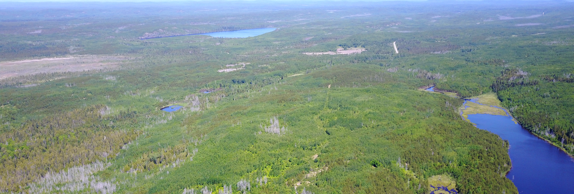
The Pichette Project is located in the Vincent Township just south of Nezah and Canadian National Highway 11 about 60 km west of the mining town of Geraldton, Ontario. The Pichette covers part of the well-endowed Beardmore-Geraldton Greenstone Gold Belt region (>4M ounces historical gold production). The Vincent Township is 28 kilometers east of the village of Beardmore and the Leitch Mine which produced 850,000 ounces of gold and 100,000 ounces of silver at an average grade of about one ounce per ton[1]. Access is excellent, with year-round paved and gravel roads to support survey and drilling work during all seasons.
[1] ONTARIO GEOLOGICAL SURVEY, Open File Report 5823, Beardmore-Geraldton Historical Research Project, By A.A. Speed and S. Craig
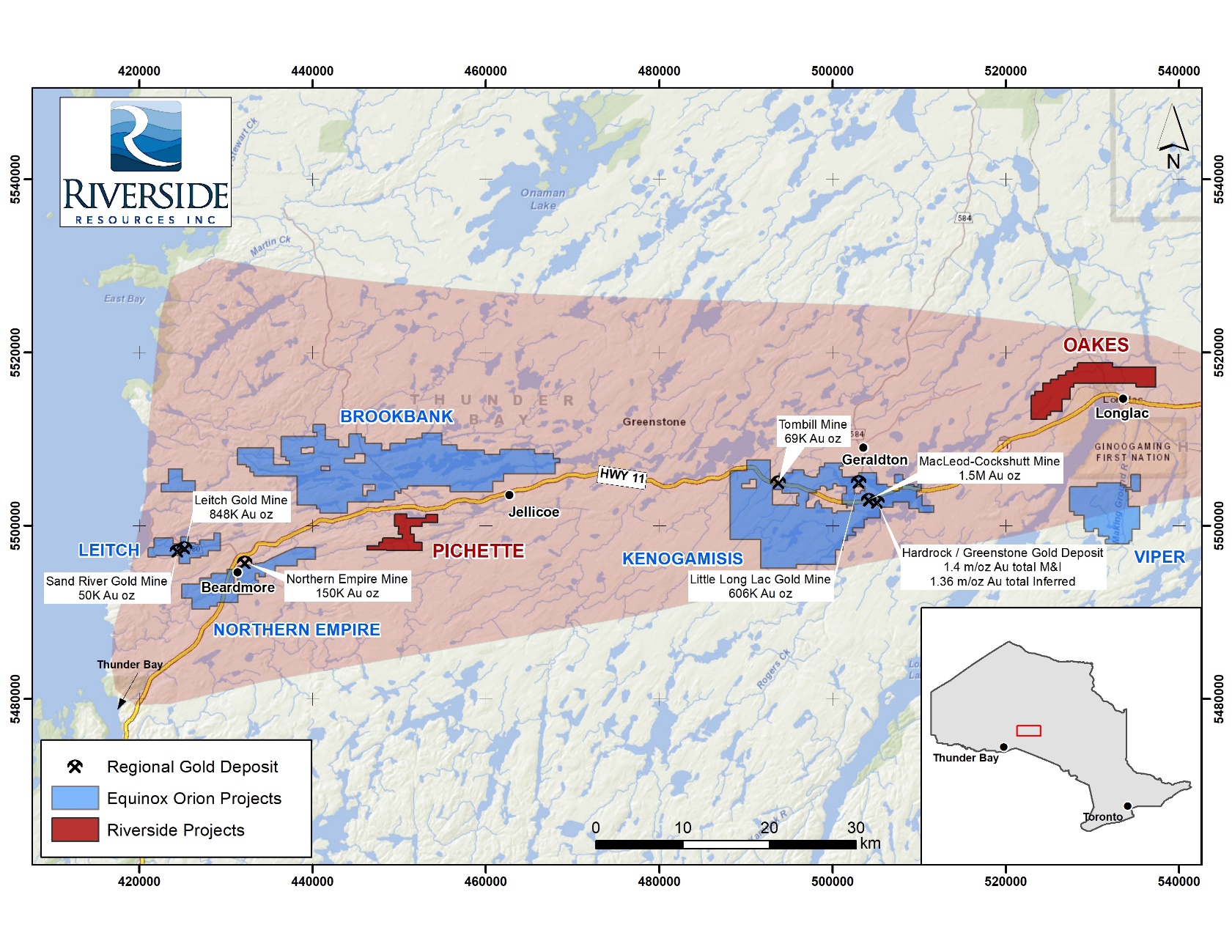
Geraldton Greenstone Belt showing the location of Longrose,
Pichette and Oakes projects with past producing mines (4.1M Oz Au in past production)
Project History
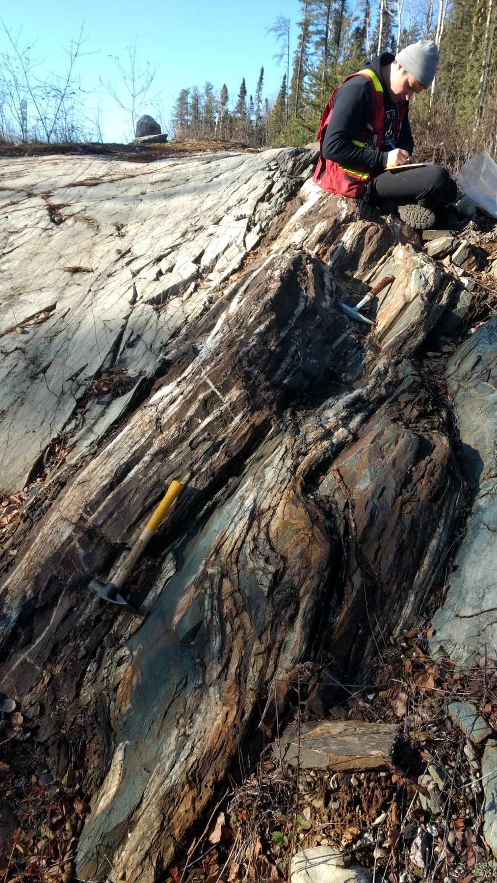
Prospectors were attracted to the area following the discovery of gold in the Beardmore and Geraldton areas in the 1930s. Assessment reports from the 1970s and 1980s indicate high-grade gold samples were collected on the project area in the 1 ounce/ton range. Prospector reports discuss rusty quartz veins showing pyrite, pyrrhotite and arsenopyrite mineralization. Past work on Riverside’s Pichette Project has included a VLF, Mag geophysics surveys in addition to two trenching and three drill campaigns.
Historical drilling (1952) by Tombill Mines focused on a series of parallel veins located near the boundary of the Beardmore Geraldton Greenstone Belt (Wabigoon) and Quetico terranes. The veins are generally associated with shears within the banded iron formation (BIF) units. The BIF units accommodate a significant amount of strain while the adjacent volcanics tend to fracture and are the host for the gold bearing quartz carbonate veins. The Tombill drilling was shallow and defined about 500m of strike. Drilling to the east was limited due to claim boundaries however these veins are considered open to the east and at depth.
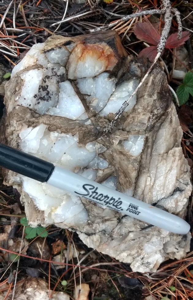
Surface sampling by Riverside in 2023 was able to locate what it believes to be a portion of one of the veins. The sampling returned high grade gold up to 21 g/t suggesting the 1950s drill target extends to surface.
Project Geology
The project is underlain predominantly by east-west trending and steeply south to vertically dipping metavolcanic and metasedimentary rocks. Metavolcanic rocks consist of massive and pillowed, locally amygdaloidal, flows of basaltic composition along with related tuffaceous rocks. They are locally intercalated with coarser-grained rocks. Mafic metavolcanic rocks are fault-bounded against domains of metasedimentary rocks closer to the center of the project. The southern metasedimentary panel consists of a polymictic conglomerate and greywackes suggesting affinity with Timiskaming Formation conglomerates in the Timmins (Porcupine) Mining District. Metasedimentary units also contain feldspathic and quartzose sandstone and wacke, siltstone, carbonaceous argillite and hematitic iron formation. Intermediate to mafic intrusions cut the metavolcanic rocks on the southern part of the property and consist of quartz diorite, diorite and gabbro and quartz porphyry.
The average width of the altered and mineralized zone is 30m consisting primarily of mafic metavolcanics and BIF. Historical drill logs suggest a sharp contact between geological units that include mafic metavolcanics, metasediments, gabbros and quartz porphyries. Historical logs also describe visible gold and carbonate veining that consists of sugary and banded quartz with massive pyrrhotite and lesser arsenopyrite and pyrite with chlorite. While no assay certificates exist for this old drilling the surface samples of up to 21 g/t gold taken by Riverside suggest high grade gold is present. This historical work was not conducted to modern NI 43-101 standards and cannot be relied upon but is included here to indicate why Riverside was working and sampling in this area. The old high-grade results will need to be verified using modern technologies and reporting methods.
Gold is commonly enriched in intensely altered rocks adjacent to or within quartz-carbonate veins and veinlets as is found in orogenic deposits. Several of the historical drill logs document high grade intercepts similar to those documented at the Leitch Gold Mine to the west at Beardmore.
Targets
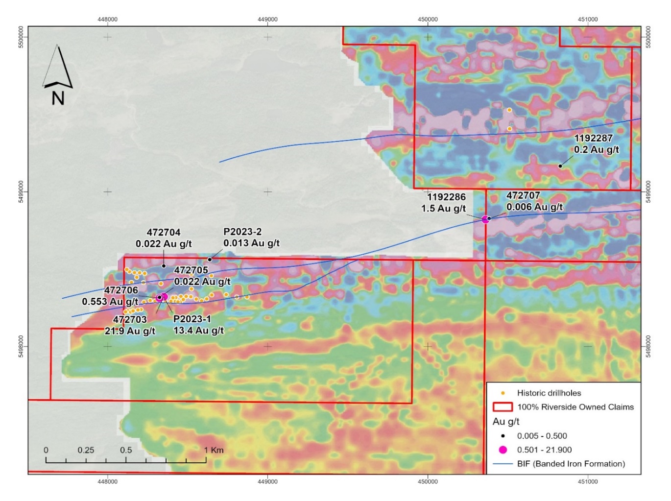
Figure 1: Sampling by Riverside in 2023
Riverside’s first-phase exploration program defined several target areas for follow-up survey work and drill target refinement (see Figure 3 below). There are several (3m wide) shear zones defined by strongly foliated material. Two of these shears were noted to be located along the boundary of iron formations as at the Pichette showing and pose a highly prospective target planned for further follow-up and potential drilling.
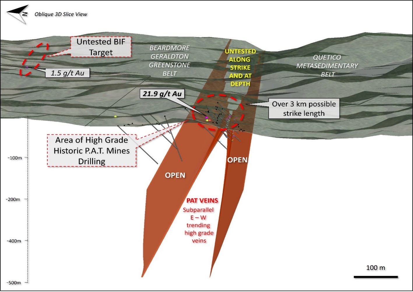
Figure 2: Drill targets identified by modelling the historical 1952 drilling (non NI43-101 compliant)
The 2022 drone magnetic survey identified several prospective targets in the east-west BGGB corridor. There is a direct relationship between structures and mineralization in the Pichette Project. Faults often function as corridors or plumbing tapping into deeper parts of the crust. Some of the structures on site indicate both sinistral and dextral components, which is to be expected, and indicates the structures have been active for a long time and had numerous opportunities for mineral precipitation and deposition. Polar diagrams of structural vein data by Riverside show a marked trend at N85E indicating a close relationship between the main structural patterns and mineralization previous interpretations invoked orogen-parallel dextral transcurrent faulting as the main structural control on the emplacement of gold mineralization in the BGB. Gold mineralization was thought to be coeval with the formation of structures and dilational zones during regional dextral transcurrent faulting, such as the hinge of Z-shaped folds, dextral shear zones at the contact between rock units, and reactivated thrust faults at the contact between panels of metasedimentary and metavolcanic rocks.
Recent work by Dr. Zsuszana Toth states that gold was emplaced earlier during the structural history of the belt and involved two stages of gold mineralization. The hydrothermal mineralization history of the Geraldton camp began with the formation of quartz-carbonate veins and early bedding-parallel Fe-carbonate alteration during D1 faulting and thrust imbrication of the belt. These veins and early Fe-carbonate alteration were folded and transposed along the Bankfield-Tombill deformation zone as panels in the belt were regionally folded and shear became localized along higher strain deformation zone during regional D2 sinistral transpression. Hydrothermal fluids flowed into the Bankfield-Tombill deformation zone, and auriferous quartz-tourmaline and quartz-carbonate veins were deposited across S-shaped folds that formed during sinistral shearing along the deformation zone. Reactivation of the deformation zone during regional D3 dextral transpression rotated and boudinaged these veins and redistributed or introduced new gold and other metals into localized dextral faults and shear zones.
The complex hydrothermal fluid history of the Geraldton Camp is recorded by the textures of pyrite grains and their chemical composition. Inclusion-poor pyrites and metal-rich, inclusion rich pyrites are associated with both syn-D1 and syn-D2 vein generations. They formed during fluid-rock sulfidation reactions with their metal content reflecting that of the hydrothermal fluids. Gold was then redistributed, or new gold and other metals were introduced, during the infiltration of late fluids along microfractures cutting across sulfide minerals and other alteration minerals. As this process occurred at different times during the formation of the Geraldton gold deposits, recent work exemplifies how the juxtaposition of multiple mineralization events and the redistribution of metals during the prolonged structural history of a major deformation zone can result in the formation of complex ore deposits (Tóth, 2019).
DEPOSIT in the Beardmore- Geraldton Greenstone Belt
The Geraldton region has a long and rich mining history and has produced 4.1 million ounces of gold over the past 100 years including the combined MacLeod-Cockshutt Mine, which produced 1.5 million ounces of gold up to 1970. The MacLeod-Cockshutt Mine at Geraldton, and the Central Patricia and Pickle Crow mines in Pickle Lake outside the BGB are non-stratiform deposits.
Non-stratiform deposits contain sulfide-rich alteration zones immediately adjacent to late structures and are like mesothermal vein-type gold deposits. Late quartz veins and/or shear zones are present in most known BIF-hosted gold deposits. The distributions of gold-bearing veins and sulfide-rich zones are commonly controlled by fold structures. Major faults of regional scale have been recognized near many non-stratiform deposits. Irregular, massive lenses of sulfides and quartz occur in a folded series of greywacke and iron formation in the Hard Rock and MacLeod-Cockshutt mines. These massive replacement lenses (up to 65%, sulfides) cut the folded iron formation and are elated to quartz-carbonate veins up to 0.6 m wide. Veins are usually barren of gold mineralization except where they contain sulfides; primarily pyrite, arsenopyrite and pyrrhotite. In other areas mineralization in veins and shears is found in metavolcanic rocks often in association with contact zones between mafic and felsic rocks.
More recently, the Hardrock Project held by Greenstone Gold Mines has elevated attention to the area by announcing their intention to mine their gold resource near Geraldton, Ontario. Greenstone Gold Mines is a 60/40 partnership between Equinox Gold and Orion Mine Finance. The deposit is centered on a complex of refolded folds where the axes of the main folds plunge at low angles to the west. The fold complex has undergone high strain brittle-ductile deformation and hydrothermal fluid flow appears to have been partly channeled. The Hardrock Project hosts 4.5M ounces in probable reserves and mineral resources 4M ounces in resources (measured and indicated). Mineralization at Hardrock is hosted in several bedrock types but primarily in tightly, folded metasedimentary metavolcanic and porphyritic rocks.
The Hardrock Deposit 55km to the east has been subject to several phases of folding through fractured rocks that developed in megascopic fold closures https://www.greenstonegoldmines.com/
To the west in Beadmore several high grade deposits have been discovered. The Lietch Mine is notable because of its high grade. The mine produced 850,000 ouces gold from 920,000 tons and is said to be the highest grade gold mine in Canada.
Deposits in the Beardmore-Geraldton Greenstone Belt
Both Beardmore and Geraldton have past producing gold mines of notable high-grade. The MacLeod-Cockshutt Mine, and the Central Patricia and Pickle Crow mines in Pickle Lake are non-stratiform deposits. Non-stratiform deposits contain sulfide-rich alteration zones immediately adjacent to late structures and are similar to mesothermal vein-type gold deposits. Late quartz veins and/or shear zones are present in most known BIF-hosted gold deposits. The distributions of gold-bearing veins and sulfide-rich zones are commonly controlled by fold structures. Major faults of regional scale have been recognized near many non-stratiform deposits. Irregular, massive lenses of sulfides and quartz occur in a folded series of greywacke and iron formation in the Hard Rock and MacLeod-Cockshutt mines (Horwood and Pye, 1951). These massive replacement lenses (up to 65%, sulfides) cut the folded iron formation and are related to quartz-carbonate veins up to 0.6 m wide. Veins are usually barren of gold mineralization except where they contain sulfides, consisting primarily of pyrite, arsenopyrite and pyrrhotite.
Qualified Person, Qa/Qc & Technical Disclosures
Regarding previous historical operators work on the Pichette Project. The reliability of historical data is uncertain but is considered to be relevant by Company management for purposes of exploration discussions (non of the historical sampling was resampled and verified). There is a risk that any confirmation work or future drill testing may produce results that substantially differ from the historical results. The scientific and technical data contained in this write-up pertaining to the Pichette Project was reviewed and approved by Freeman Smith, P.Geo, a non-independent qualified person to Riverside Resources, who is responsible for ensuring that the geologic information provided in this news release is accurate and who acts as a “qualified person” under National Instrument 43-101 Standards of Disclosure for Mineral Projects.